

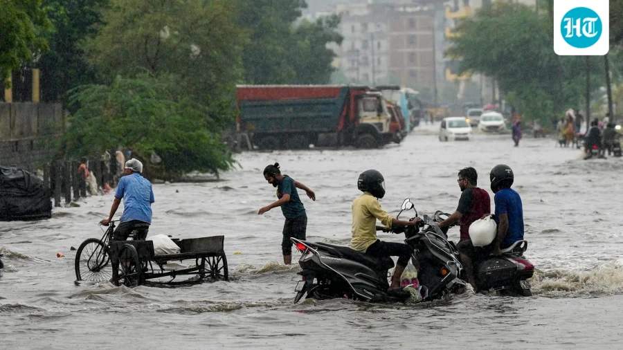
This week, residents of Delhi and Meerut woke up to a sight more familiar to Mumbaikars: relentless rain turning roads into rivers, waterlogging that stalled traffic, and a sky that refused to clear. For many, it felt like the monsoon had temporarily shifted its address from the western coast to the northern plains. But why did this happen? The answer lies in the physics of rainfall — and a rare alignment of atmospheric conditions.
The physics of rainfall: Why Mumbai gets it, Delhi usually doesn’t
Mumbai’s heavy rain is no accident. The city sits on the windward side of the Western Ghats, where moisture-laden winds from the Arabian Sea are forced to rise. As the air climbs, it cools, condenses, and releases torrential rain — a process called orographic precipitation. Delhi and Meerut, by contrast, are far from any such mountain barrier. Their rain typically comes from the monsoon trough, a low-pressure zone that moves across northern India, but it is rarely as intense or sustained as Mumbai’s.
What changed this week: A rare convergence of factors
This week, a combination of an active monsoon trough, a cyclonic circulation over northwest India, and an influx of moisture from the Bay of Bengal created a perfect storm. The trough, which usually lies over the Gangetic plains, shifted westward, pulling in deep moisture. This moisture, combined with atmospheric instability — warm air rising rapidly — triggered intense convection. The result: clouds that towered high into the atmosphere, producing rainfall rates similar to those seen on the western coast.
How the downpour unfolded: From alert to impact
The India Meteorological Department (IMD) had issued an orange alert for Delhi and parts of western Uttar Pradesh days before the event, warning of heavy to very heavy rainfall. On the day of the heaviest downpour, Safdarjung Observatory in Delhi recorded over 100 mm of rain in 24 hours — a figure that rivals Mumbai’s average July daily rainfall. In Meerut, some areas reported even higher totals, with streets flooding within hours. The rapid accumulation overwhelmed drainage systems, leading to waterlogging that disrupted daily life.
Who felt the impact most: Commuters, students, and daily wage workers
The rain hit hardest those who could least afford it. Commuters faced hours-long delays on roads and metro lines. Schoolchildren in Delhi and Meerut saw classes disrupted as water entered classrooms. Daily wage workers, especially those in construction and street vending, lost a day’s income. For many, the rain was not just a weather event — it was a reminder of how vulnerable urban infrastructure is to extreme weather, even when it is rare.
IMD’s response and what they are saying
The IMD has attributed the event to an active monsoon trough and a cyclonic circulation over northwest India. In a statement, officials said the trough is likely to remain active for the next few days, with more rain expected. “This is not typical for Delhi in June, but it is within the range of variability we see during an active monsoon phase,” a senior IMD scientist told reporters. The agency has advised residents to stay indoors during heavy spells and avoid waterlogged areas.
Why this rain was so intense: The science of convective rainfall
Unlike Mumbai’s steady orographic rain, the downpour in Delhi and Meerut was convective — driven by rapid upward motion of warm, moist air. When the atmosphere is unstable, as it was this week, air rises quickly, forming tall cumulonimbus clouds. These clouds can release enormous amounts of rain in a short time, often leading to flash flooding. The moisture from the Bay of Bengal, which is unusually warm this year, added extra fuel to the system, making the rain more intense than usual.
Confirmed facts vs what remains unclear
Confirmed: Delhi and Meerut received over 100 mm of rain in 24 hours this week, comparable to Mumbai’s monsoon intensity. The IMD issued an orange alert before the event. The rain was caused by an active monsoon trough and a cyclonic circulation. Unclear: Whether this event is linked to climate change — attribution studies take months. Also unclear: Whether such intense rain will become more common in northern India, though some climate models suggest an increase in extreme events.
Risks and balanced view: The downside of rare heavy rain
While the rain brought relief from heat, it also exposed weaknesses. Delhi’s drainage system, designed for lighter, more sporadic rain, was overwhelmed. Waterlogging led to traffic jams, flight diversions, and damage to property. Some experts warn that if such events become more frequent, the city will need to invest in better stormwater management. On the other hand, the rain also replenished groundwater and reduced the need for irrigation in nearby farmlands — a silver lining for agriculture.
Wider trend: Is northern India seeing more extreme rain?
This event fits a broader pattern observed in recent years: northern India, including Delhi and Uttar Pradesh, has seen an increase in short-duration, high-intensity rainfall events. A 2023 study by the Indian Institute of Tropical Meteorology found that extreme rain events in central and northern India have risen by 10-15% over the past five decades. While this week’s rain cannot be directly attributed to climate change, it aligns with what scientists expect in a warming world: more moisture in the air, leading to heavier downpours.
Practical guidance: What residents should do now
For those in Delhi, Meerut, and surrounding areas, the IMD advises staying updated through its official app or website. Avoid driving or walking through waterlogged roads — even shallow water can hide open manholes or electrical hazards. Keep emergency numbers handy, and ensure drainage around your home is clear. If you live in a low-lying area, consider moving valuables to higher ground. For farmers, the rain is beneficial for kharif crops, but ensure fields are not waterlogged for too long.
Future outlook: What could happen next
The monsoon trough is expected to remain active over the next week, with the IMD predicting more rain for Delhi-NCR and western Uttar Pradesh. However, the intensity may decrease as the cyclonic circulation weakens. In the longer term, climate models suggest that northern India could see more such events, especially if sea surface temperatures in the Bay of Bengal continue to rise. Urban planners may need to rethink drainage and flood management to cope with a changing monsoon.
Our Take
This week’s rain was a rare and dramatic reminder that weather is not static. For Delhi and Meerut, it was a glimpse into a future where extreme events may become more common — and a test of how prepared our cities are. The physics of rainfall is clear: when moisture and instability align, even the driest regions can see Mumbai-like downpours. The question is whether our infrastructure, and our awareness, can keep pace.
Frequently Asked Questions
Why did Delhi and Meerut get so much rain this week?
An active monsoon trough combined with a cyclonic circulation over northwest India pulled in deep moisture from the Bay of Bengal. Atmospheric instability caused rapid upward motion of air, leading to intense convective rainfall — similar to what Mumbai experiences from orographic lifting.
Is this rain linked to climate change?
Attribution studies take months to complete, so it is too early to say definitively. However, the event aligns with climate models that predict more extreme rainfall in northern India due to a warming atmosphere holding more moisture.
How much rain did Delhi and Meerut receive?
Delhi’s Safdarjung Observatory recorded over 100 mm in 24 hours, while some parts of Meerut saw even higher totals. This is comparable to Mumbai’s average July daily rainfall.
What should I do if I am caught in heavy rain?
Stay indoors if possible. Avoid driving or walking through waterlogged roads. Keep emergency numbers handy. Monitor IMD alerts through their official app or website.