

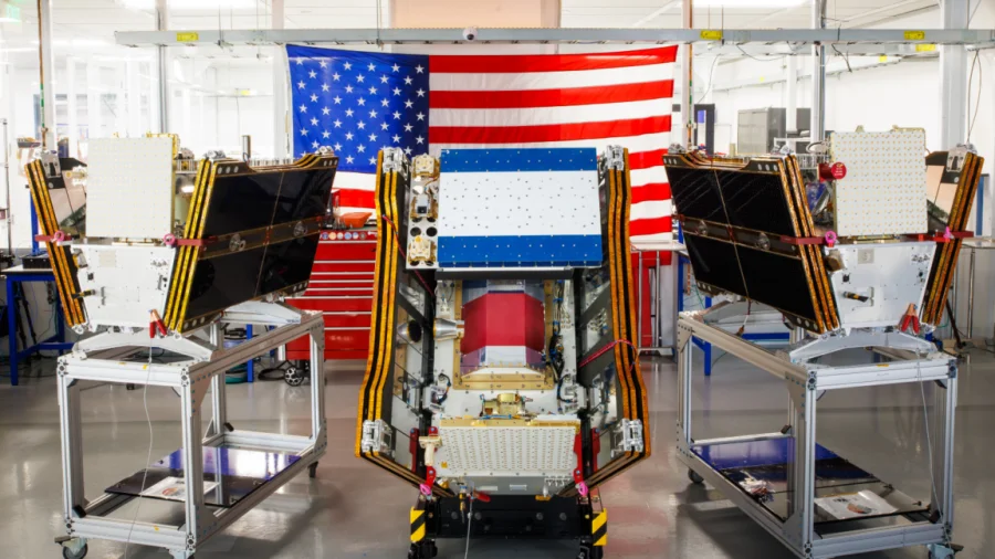
As smoke from hundreds of burning wildfires spread across Canada and the United States, the first three operational satellites in the Google-backed FireSat program successfully launched into orbit. The launch, which took place aboard a SpaceX Falcon 9 rocket from Vandenberg Space Force Base in California on July 7, 2026, marks a critical step in the fight against increasingly destructive wildfires.
What FireSat satellites will do for wildfire detection
The FireSat constellation, managed by the nonprofit Earth Fire Alliance, is designed to detect even small fires before they grow into catastrophic blazes. After a three-month testing period, the three microsatellites will begin actively providing data to fire agencies while covering every fire-prone region on Earth at least twice per day. This capability is expected to significantly improve response times for firefighters and emergency services.
Why this launch matters as smoke chokes millions
The launch comes at a time when smoke from hundreds of wildfires has spread across large parts of the United States and Canada, affecting air quality for millions of people. Early detection of small fires could help prevent them from escalating into massive infernos that produce dangerous smoke plumes, reducing both property damage and public health risks. For communities in fire-prone regions, the FireSat constellation offers a new layer of protection.
How the FireSat constellation works
The three microsatellites are part of a planned larger constellation that will eventually provide near-continuous monitoring of fire-prone areas. Each satellite is equipped with advanced sensors capable of detecting heat signatures from small fires, even in remote or difficult-to-access locations. The data will be shared with fire agencies in the United States, Australia, and Europe before the end of 2026, with plans to expand coverage globally.
Who is affected by wildfire smoke and the new detection system
Residents across the US and Canada have been grappling with hazardous air quality as smoke from hundreds of wildfires spreads across the continent. Vulnerable populations, including children, the elderly, and those with respiratory conditions, are at heightened risk. The FireSat system aims to reduce the frequency and severity of such events by enabling faster detection and response, potentially saving lives and reducing economic losses.
Earth Fire Alliance and Google's role in the project
The Earth Fire Alliance, a nonprofit organization, manages the FireSat constellation with backing from Google. Google has provided funding and technical expertise, including machine learning algorithms to analyze satellite data and distinguish between actual fires and false positives. The partnership reflects a growing trend of technology companies contributing to climate resilience and disaster management efforts.
What the launch means for firefighting agencies
For fire agencies in the US, Australia, and Europe, the FireSat constellation represents a significant upgrade in detection capabilities. Traditional satellite-based detection systems often struggle to identify small fires due to lower resolution or infrequent passes. FireSat's dedicated constellation ensures more frequent and accurate monitoring, allowing firefighters to respond before fires become uncontrollable.
Confirmed facts vs what remains unclear
Confirmed: Three FireSat microsatellites launched on July 7, 2026, aboard a SpaceX Falcon 9 rocket. The constellation is managed by Earth Fire Alliance with Google backing. After a three-month testing period, the satellites will provide data to fire agencies in the US, Australia, and Europe. Unclear: The exact timeline for expanding the constellation to additional satellites, the total cost of the program, and how the system will integrate with existing fire detection infrastructure.
Risks and balanced view of the FireSat program
While the FireSat constellation offers promising capabilities, challenges remain. The system's effectiveness depends on the number of satellites deployed and their ability to cover all fire-prone regions. Critics may question whether the constellation can scale quickly enough to address the growing wildfire crisis. Additionally, reliance on satellite data requires robust ground-based infrastructure and trained personnel to act on the information. The program's success will ultimately depend on sustained funding and international cooperation.
Wider trend: Tech companies stepping into climate disaster response
The FireSat launch is part of a broader trend of technology companies investing in climate resilience tools. From AI-powered weather forecasting to satellite-based monitoring, private sector involvement is reshaping how governments and agencies respond to natural disasters. Google's backing of FireSat reflects a recognition that early detection and rapid response are critical to mitigating the impacts of climate change.
Practical guidance for communities affected by wildfire smoke
For residents in areas affected by wildfire smoke, health officials recommend staying indoors, using air purifiers, and wearing N95 masks when outdoors. Monitoring local air quality indexes and following evacuation orders are essential safety measures. The FireSat system, once operational, could provide earlier warnings, giving communities more time to prepare and respond.
Future outlook for the FireSat constellation
The initial three satellites are expected to begin operational data sharing by the end of 2026. Plans to expand the constellation with additional satellites could improve coverage and detection frequency, potentially covering every fire-prone region on Earth multiple times per day. The success of this initial phase will likely determine the pace of future deployments and the program's long-term impact on wildfire management.
Our Take
The launch of the FireSat constellation is a timely and necessary development as wildfires become more frequent and intense due to climate change. While the program is still in its early stages, the potential to detect small fires before they escalate could save lives, reduce property damage, and improve air quality for millions. However, the system's success will depend on continued investment, international collaboration, and effective integration with existing firefighting infrastructure. For now, the launch offers a glimmer of hope amid the smoke.
Frequently Asked Questions
What is the FireSat constellation?
The FireSat constellation is a network of microsatellites designed to detect wildfires early. Backed by Google and managed by the nonprofit Earth Fire Alliance, the satellites can spot even small fires and provide data to fire agencies in near real-time.
When will FireSat satellites start detecting wildfires?
After a three-month testing period, the three launched satellites will begin actively providing data to fire agencies in the United States, Australia, and Europe before the end of 2026.
How does FireSat differ from existing wildfire detection systems?
FireSat uses dedicated microsatellites with advanced sensors to detect small fires more frequently and accurately than traditional satellite systems, which often have lower resolution or less frequent passes over fire-prone areas.
Who can access FireSat data?
FireSat data will be shared with fire agencies in the US, Australia, and Europe initially, with plans to expand coverage globally. The data is intended to help firefighters respond faster and more effectively.